BUILT FOR MICROSOFT FLIGHT SIMULATOR

From SimBrief planto cockpit.

Prepare, track and master every phase of your IFR flight in an interface that speaks the language of pilots.

Native Windows application Data stays on your computer Direct connection to MSFS
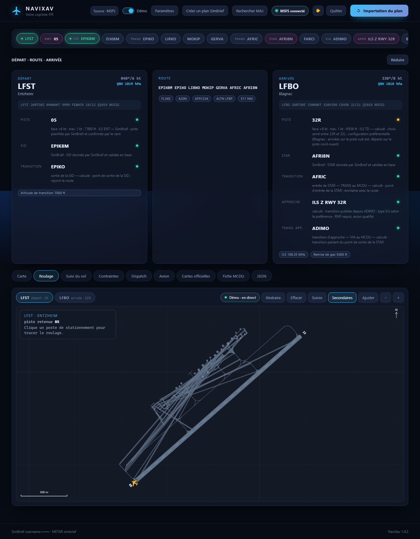
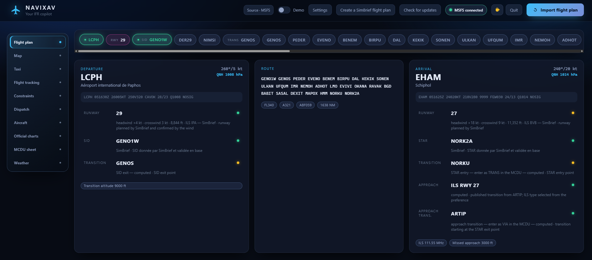
Real NaviXav interface: Flight plan module for the LCPH to EHAM flight, with departure, route and arrival
REAL SCREENSHOT · NAVIXAV 1.4.9 · LIVE SIMCONNECT
EXPLORE
SIMBRIEF OFP+MSFS SIMCONNECT+AIS OFFICIEL+MÉTÉO METAR/TAF=ONE COCKPIT
01 A NEW WAY TO FLY

Less searching.
More flying.

No more scattered windows, repeated data entry or details lost between planning and flight. A module rail — flight plan, map, taxi, tracking, constraints, dispatch, aircraft, official charts, MCDU sheet, weather — opens every step without leaving the screen.

01PREPARE
Real NaviXav Flight plan moduleREAL SCREENSHOT

Your OFP, made clear.

The Flight plan module picks up your latest SimBrief plan and lays departure, route and arrival side by side: runway, SID, transition, STAR, approach and transition altitude, each with its source and confidence level.
02PROGRAM
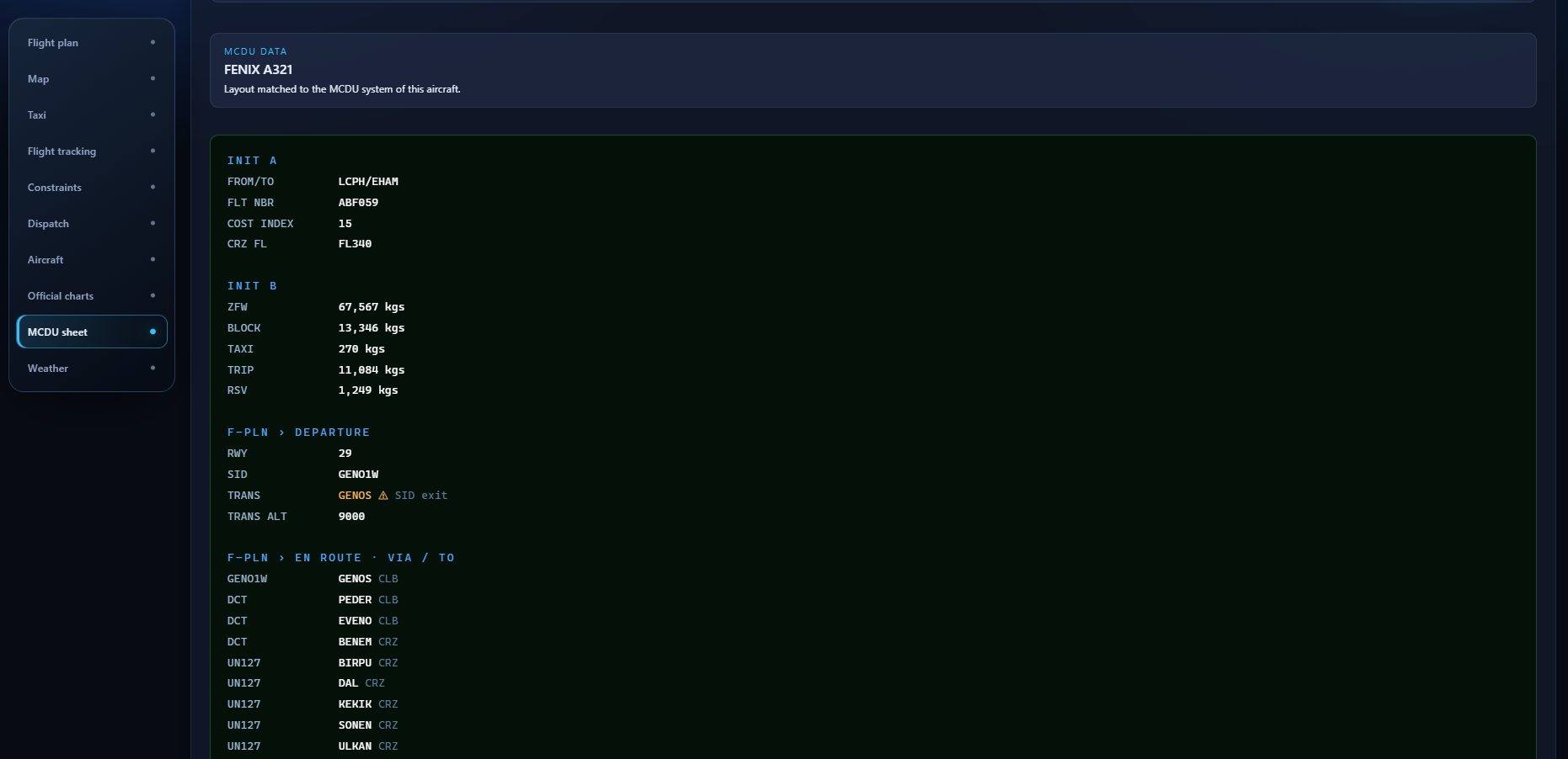
Real NaviXav MCDU sheetREAL SCREENSHOT

MCDU entry, without the back-and-forth.

A dedicated sheet for Airbus, Boeing or a generic FMS lays out INIT A, INIT B and the flight plan in the order you type them, and flags whatever needs your attention.

03FLY
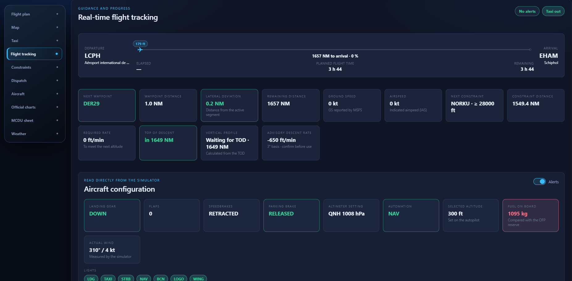
Real NaviXav flight trackingREAL SCREENSHOT

Stay one step ahead.

Position, next waypoint, lateral deviation, Top of Descent, next constraint and aircraft configuration update live through SimConnect.

02 THE FLIGHT STARTS ON THE GROUND
NaviXav Taxi module showing the Paphos airport layout, the route from stand 4 to runway 29 and the current instruction
REAL TAXI MODULE · LCPH · LIVE SIMCONNECT

Ground taxi.
Finally readable.

A dedicated module shows the aerodrome on its own, on a dark aeronautical background: no road basemap, no flight route. NaviXav recognises the stand your aircraft is parked at, suggests its route to the selected runway and names only the taxiways you are going to use.

Suggested routeThe stand nearest the aircraft is detected at departure. Clicking another one instantly redraws the path.

Current instructionThe next instruction is shown large, with the remaining path and the distance to the end.

Uncluttered fieldSecondary taxiways hidden by default, metric grid and north indicator.

03 THE RIGHT SIGNAL, AT THE RIGHT TIME

Your flight.
In real time.

NaviXav turns simulator data into useful cues — without drowning you in numbers.

01

Dynamic progressFlight phase, next waypoint, lateral deviation and remaining distance.

02

Vertical profileTop of Descent, rate required for the next constraint and advisory descent rate.

03

Configuration read from the simulatorGear, flaps, speedbrakes, parking brake, altimeter setting, automation, lights and fuel on board.

04

Flight timelineEvery phase and every meaningful change is logged, then kept with the flight summary.

Real flight tracking and aircraft configuration interface in NaviXav
REAL FLIGHT TRACKING MODULE · LIVE SIMCONNECT
04 NEVER DESCEND TOO EARLY

Every constraint.
Laid out, not summarised.

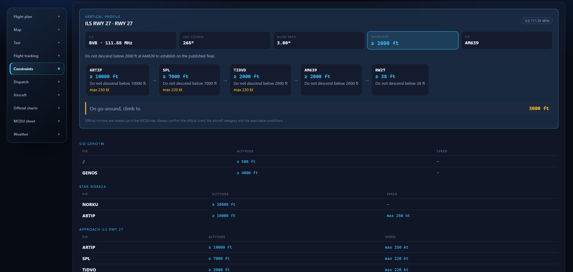
The Constraints module opens the vertical profile of the selected approach, then the chain of steps to respect down to the threshold. The tables underneath list the published constraints of the SID, the STAR and the approach in your plan.

Approach profileILS identifier and frequency, localiser course, glide path, intercept altitude, associated fix and go-around altitude.

Step-down chainEvery fix shows the altitude you must not descend below and its published speed limit, in flight order.

Procedure recapSID, STAR and approach keep their full tables, altitude and speed fix by fix.

NaviXav Constraints module: vertical profile of the ILS RWY 27 at EHAM with SID, STAR and approach constraint tables
REAL CONSTRAINTS MODULE · ILS RWY 27 · EHAM
05 DIRECT FROM THE SOURCE

Official charts.
Inside your workflow.

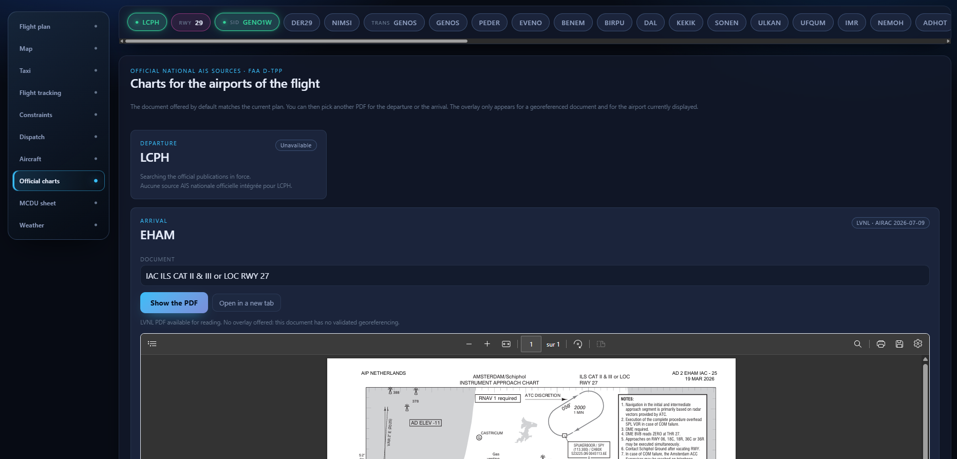
Browse national authority publications directly in NaviXav. The app finds the document that matches your departure, arrival and approach, shows the AIRAC cycle in force, and only offers a map overlay when the document is genuinely georeferenced.

FRSIA eAIPESENAIRE AIPNLLVNL eAIPUSFAA d-TPP
NaviXav Official charts module showing the LVNL ILS RWY 27 approach chart for Amsterdam Schiphol
REAL OFFICIAL CHARTS MODULE · LVNL · AIRAC 2026-07-09
06 WEATHER AND DISPATCH

The weather ahead.
The fuel you have left.

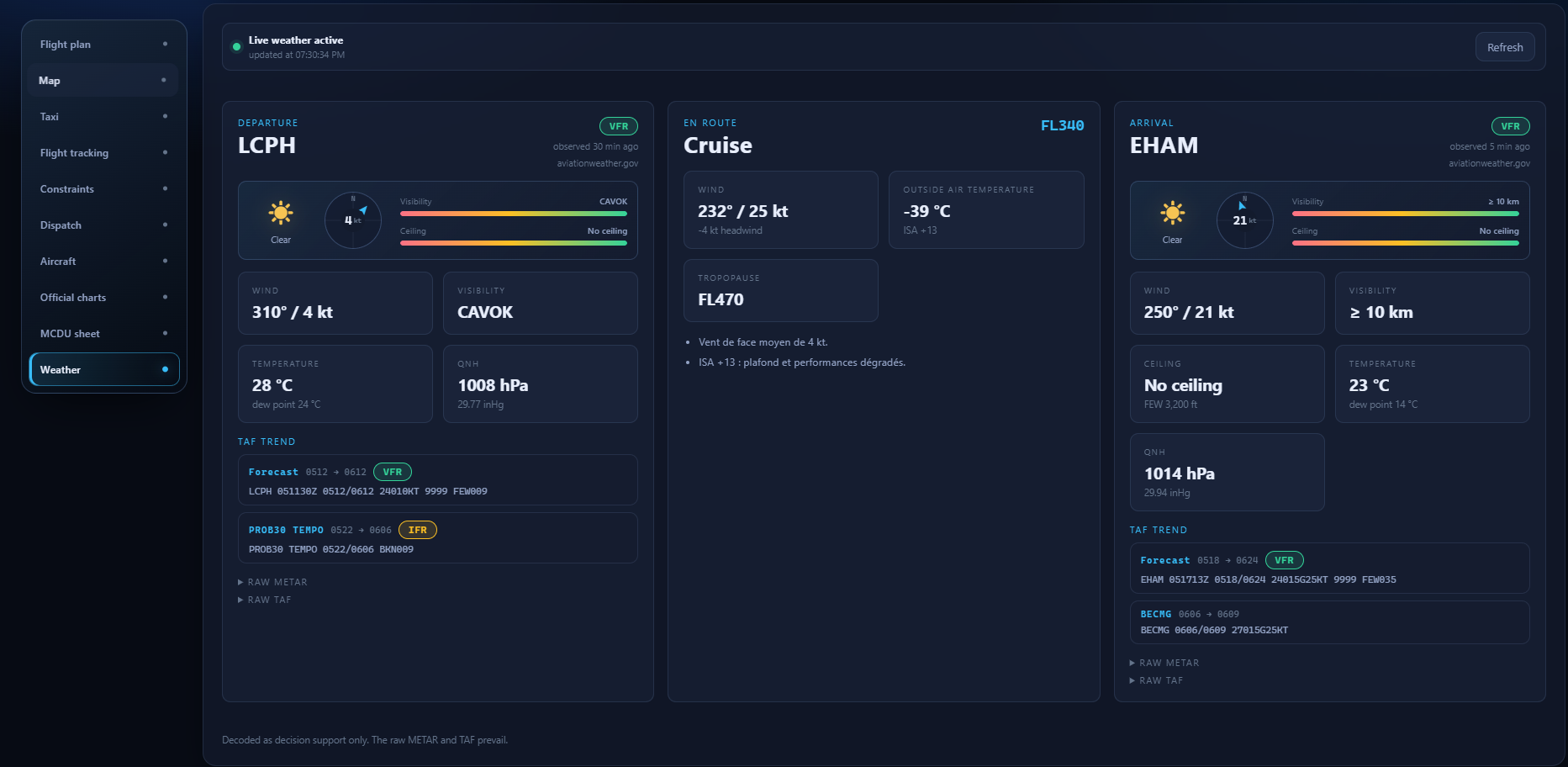
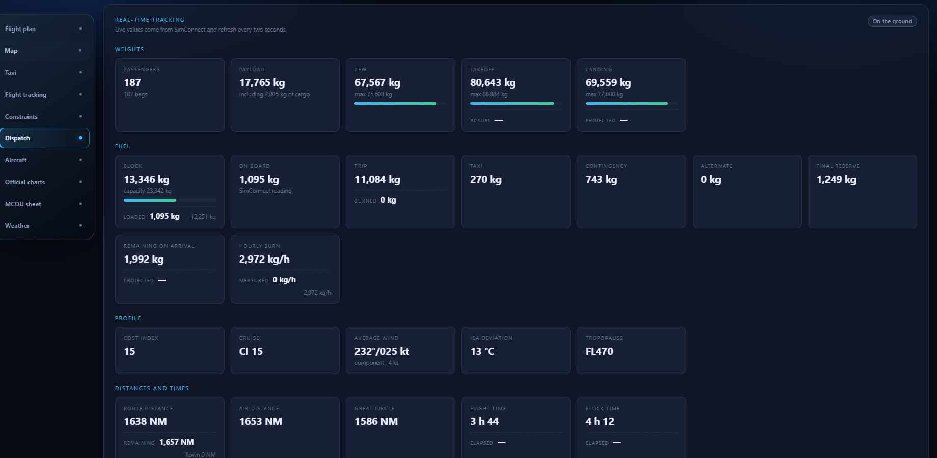
The Weather module gathers the departure, cruise and arrival briefings. The Dispatch module compares your OFP forecast against what the simulator actually measures, while you fly.

Decoded briefingWind, visibility, ceiling, temperature, dew point, QNH, significant phenomena and flight category, with the age of the observation.

TAF trendThe TAF is summarised down to its significant change windows. Raw METAR and TAF messages stay one click away.

CruiseMean wind, component, ISA deviation, outside air temperature and computed tropopause.

Live deviationWeights, block fuel, hourly burn, times and distances are compared against the OFP and refresh every two seconds.

Alerts that matterProjected arrival fuel below final reserve plus alternate, landing weight above maximum.

NaviXav Weather module: decoded briefings for LCPH, the cruise and EHAM with the TAF trend
REAL WEATHER MODULE · LCPH → EHAM
NaviXav Dispatch module: weights, fuel, profile and distances compared against the OFP
REAL DISPATCH MODULE · LIVE WEIGHTS AND FUEL
07 LOCAL BY DESIGN

Your cockpit.
Your data.

NaviXav runs in its own Windows window. Your settings, navigation cache and flight summaries stay on your computer.

Learn more about NaviXav
NAVIXAV / LOCAL SYSTEMPROTECTED
INTERFACEDedicated Windows windowLOCAL
SERVICE127.0.0.1 onlyLOCAL
NAVDATAMSFS cache on your PCLOCAL
LOGSNo SimBrief identifierPRIVATE
NO FLIGHT DATA UPLOADED4/4
08 TRANSPARENCY

Built by vibe coding.
And owning it.

NaviXav is a solo project built with coding assistants. Nearly all of the code — the application as well as this website — is written through a dialogue with language models, then reviewed, flown and fixed. Better to say it plainly than to let you work it out on your own.

DEVELOPMENT TOOLING
CLAUDE CODEOPENAI CODEXPYTHONNEXT.JS
Read the code on GitHub
01

What it changesReleases come quickly and so do features. Bugs slip through too: the changelog lists them without dressing them up.

02

What it does not changeEvery release is flown before it ships, and the downloaded installer is checked against its SHA-256 checksum before any automatic update.

03

Your right to checkThe code is public on GitHub. You can read it, fix it, or report what is wrong.

READY FOR YOUR NEXT DEPARTURE?

Your IFR flight.
Finally in one place.

Install NaviXav on Windows, launch MSFS and turn your next OFP into a smoother flight experience.

Download NaviXav For Microsoft Flight Simulator · Simulation use only
Enjoying the project?

NaviXav remains accessible to everyone. If you like it, you can support its development with a simple coffee.

Buy me a coffee
09 FREQUENTLY ASKED QUESTIONS

Before
takeoff.

01Does NaviXav replace SimBrief?+

No. It turns your latest SimBrief OFP into a cockpit-oriented preparation and tracking experience, then enriches it with native MSFS data.

02Do I need to install or replace SimConnect?+

No. NaviXav uses its own private application library and talks to the SimConnect service already provided by Microsoft Flight Simulator.

03Does my flight data leave my PC?+

No. Settings, navigation cache and flight summaries remain local. NaviXav never stores your SimBrief identifier in its logs.

04Which official charts are available?+

Current connectors query SIA in France, ENAIRE in Spain and the Canary Islands, LVNL in the Netherlands and the FAA in the United States directly.

05Does NaviXav guide ground taxi?+

The “Taxi” module draws the route between your parking stand and the selected runway from Microsoft Flight Simulator terrain data, then shows the current instruction and the remaining distance. It replaces neither air traffic control nor official aerodrome charts.

06Where does the weather data come from?+

The “Weather” module briefings are built from the METAR and TAF of the relevant stations, decoded inside the app. In direct METAR mode, observations refresh every five minutes without recalculating the route, and the age of each observation stays visible.

07Is NaviXav’s code written by an AI?+

Largely, yes. NaviXav is a solo project built with vibe coding: features are written through a dialogue with coding assistants (Claude Code, OpenAI Codex), then reviewed, flown and fixed. This website follows exactly the same method. The code stays public on GitHub, readable and open to criticism by anyone.